Recently, in the report of Climate Change Center Himachal and Space Application Center (ISRO) Ahmedabad, it has been revealed that the snow-covered area is continuously decreasing in Himachal Pradesh. This is a matter of concern for the whole of Himachal and North India because the agricultural economy of India directly rests on the waters of the rivers originating from Himachal and especially the Himalayas. If the situation continues like this, then it will also become a question of water security of the country.
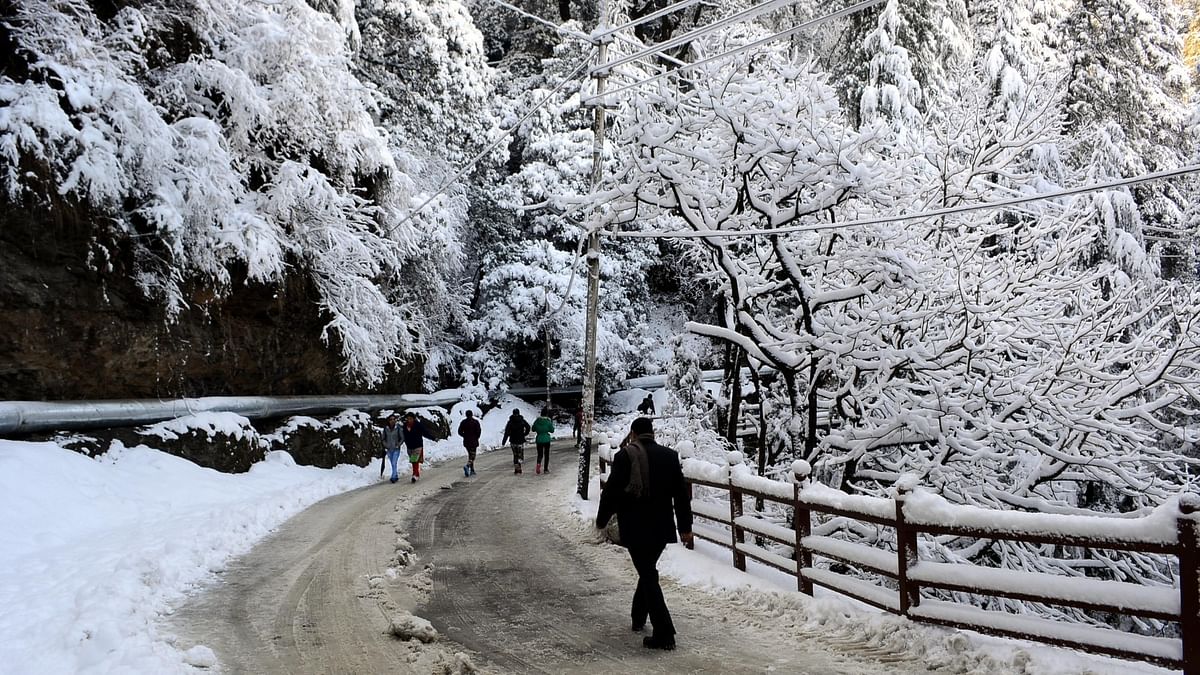
The high altitude regions of Himachal Pradesh receive only snow in the form of snow during the winter season. One-third of the geographical area of the state is covered by a thick blanket of snow during the winter season. Rivers and tributaries like Chenab, Beas, Parvati, Baspa, Spiti, Ravi, Sutlej flowing through Himachal are dependent on snowfall in winter. This snow melts and irrigates the extensive agricultural plains of North India. Not only this, these rivers are the lifelines of the economy of Himachal Pradesh.
The autumn season from October to May has been evaluated by the above departments. This assessment is done using images and data received from satellites. Experts believe that snow is an essential resource for the Himalayas. The study of snowfall is essential for hydrology and climatology. Studying the snowfall in Chenab, Beas, Ravi and Sutlej basins, it has been found that there has been a significant reduction in snowfall during this year i.e. October 2020-May 2021 as compared to last year i.e. 2018-19.
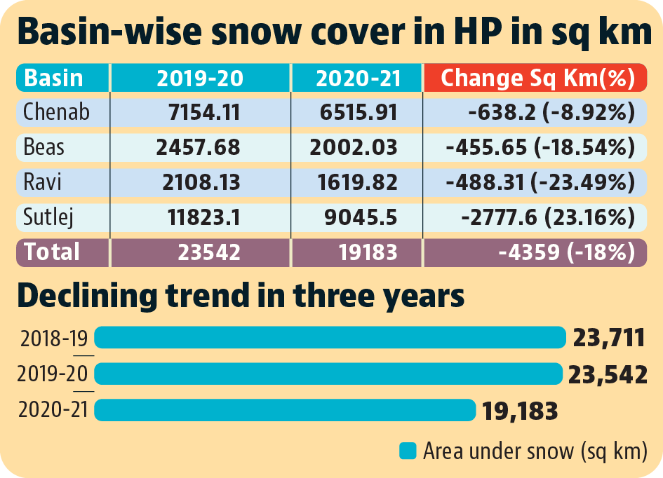
There has been an average decrease of 8.92 percent in Chenab basin, 18.54 percent in Beas basin, 23.16 percent in Ravi basin, 23.49 percent in Sutlej basin compared to last year. These shortages indicate a very serious situation. The ice covered area of Chenab basin was 7154.11 sq km in 2019-20, which has come down to 6515.91 sq km in 2020-21. Similarly, Beas basin was reduced from 2457.68 to 2002.03 square kilometer, Ravi basin from 2108.13 square kilometer to 1619.82 square kilometer and Sutlej from 11823.1 square kilometer to 9045 square kilometer. Overall, the snow covered area was reduced from 23542 square kilometer to 19183 square kilometer in the entire Himachal.
The above study shows that the maximum reduction in snow cover has occurred in the Sutlej basin. Where the area of 2778 square kilometers has been reduced directly. The area of 4359 square kilometers in the entire Himachal has decreased, out of which more than half of the Sutlej Basin alone is a matter of concern for environmentalists. The Sutlej River is the longest river here, which also includes Baspa and Spiti river basins. If the size of the entire Sutlej basin is seen, then including the part of Tibet, it sits at 22665 square kilometers.
On this, Prakash Bhandari of the environmental study group Himdhara says in a worried tone, there is no one reason for this, many reasons have created this situation together and it should be studied closely. The real thing is that if the glaciers keep melting like this, then it will become a threat to the water security of North India. It is global warming that is causing changes in the climate on a global scale. Local weather also plays a role in reducing or increasing its effects. If we can control large hydropower projects, tourism and other development activities in the high Himalayan regions, then the rate of extinction of glaciers can be reduced. This is also necessary because the area where all this is happening is also a strategically important area for India.
This concern is also heightened by the fact that a new report released by the World Meteorological Organization (WMO), ‘2021 State of Climate Services’ claims, 1 cm of terrestrial water storage over 20 years (2002–2021). . The rate of decline has been recorded every year. These regions include India, where collections have declined at a rate of at least 3 cm per year. In some areas this fall is 4 cm. has been more than per year. According to WMO analysis, India is the ‘biggest hotspot of decline in terrestrial water storage’. The highest decline has been recorded in the northern part of India. Water is a major basis for human development. But only 0.5 percent of the total water available on earth is usable and is available as fresh water.
Generally it can be said that this is happening due to climate change globally. But if we look specifically at the activities around Himachal, we will find that big dams, cement industries, roads and other big projects built in the name of development are clearly responsible for this. These directly affect the local weather. The Sutlej river is the perfect example to understand this. The snow-covered area of the Sutlej basin has been the least and the study reports of environmental groups have found that this river also has the highest number of dams. The entire Sutlej river has been converted into dams. At the bottom is the Bhakra Dam which has a size of 168 sq km and a storage capacity of 9.340 cubic km. Is. This is followed by the Kol Dam which extends for 42 km up to Sunni, which has a total storage capacity of 90 million cubic metres. Nathpa Jhakri Project which is 27.394 kms. is long.
The report titled Hidden Coast of Hydro Power claims that the total hydroelectric potential of Himachal is 27,436 MW and that of the Sutlej river alone is 13,322 MW. That is why most of the hydroelectric projects are being set up on the Sutlej river itself. As of now there are 27 hydel power projects established and 8 under construction in Himachal. Kinnaur continues to be a hydel power powerhouse across the country with 10 running of the river projects in progress and 30 to be set up including two mega projects of 1500 MW and 1000 MW each. They paint a scary picture. It is also a matter of thinking that if there is no snow cover area then what will happen to these projects?
When a dam is built, a huge amount of water is stored. The debris of many villages, trees etc. also gets absorbed inside the dam. When water is stagnant, it receives heat from the Sun to form mist in the surrounding area by evaporation and simultaneously generates methane gas. The experience of the lake formed by the Kol dam at Tattapani in Mandi district shows that the area is experiencing heavy haze which was not there earlier. In the 30s and 40s, Shikari Devi and Kamrunag used to have snow on the peaks for about 6 months, which now could barely stop for only 2 months. The air route distance of Shikari Devi and Kamrunag is only 26 to 30 kms from Tattapani lake. At the same time, their distance is not much from the cement factories of Darlaghat, Sundernagar. The elders of the area say that the smog has increased the heat in the area. Due to the warming of the weather due to the clouds formed from the mist, the snow has started melting quickly. The elders say that factories and dams have ruined their area. These dams have also affected the crops.
If the expansion of big dams, hydroelectric projects and factories continues in Himachal in the same way, then the day is not far when the earth will start heating like the plains and due to this change in climate will ruin the agriculture and horticulture here. It is to be noted that hydropower projects which are being projected as “Green Energy”, while these same projects are one of the major reasons for climate change in the high Himalayan regions.
From Himdhara (Environment Research and Action Collective)